
25/07/2019
Exciting New Features Announced for 2019 Haute Route San Francisco Course
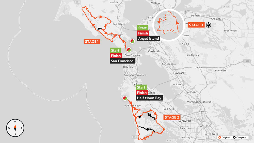
The course for the 2019 Haute Route San Francisco will take riders on a unique and challenging tour of the Bay Area, including a classic ride through Marin County, a new route from Half Moon Bay, and the return of the exclusive Angel Island Time Trial.
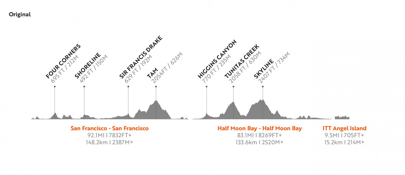
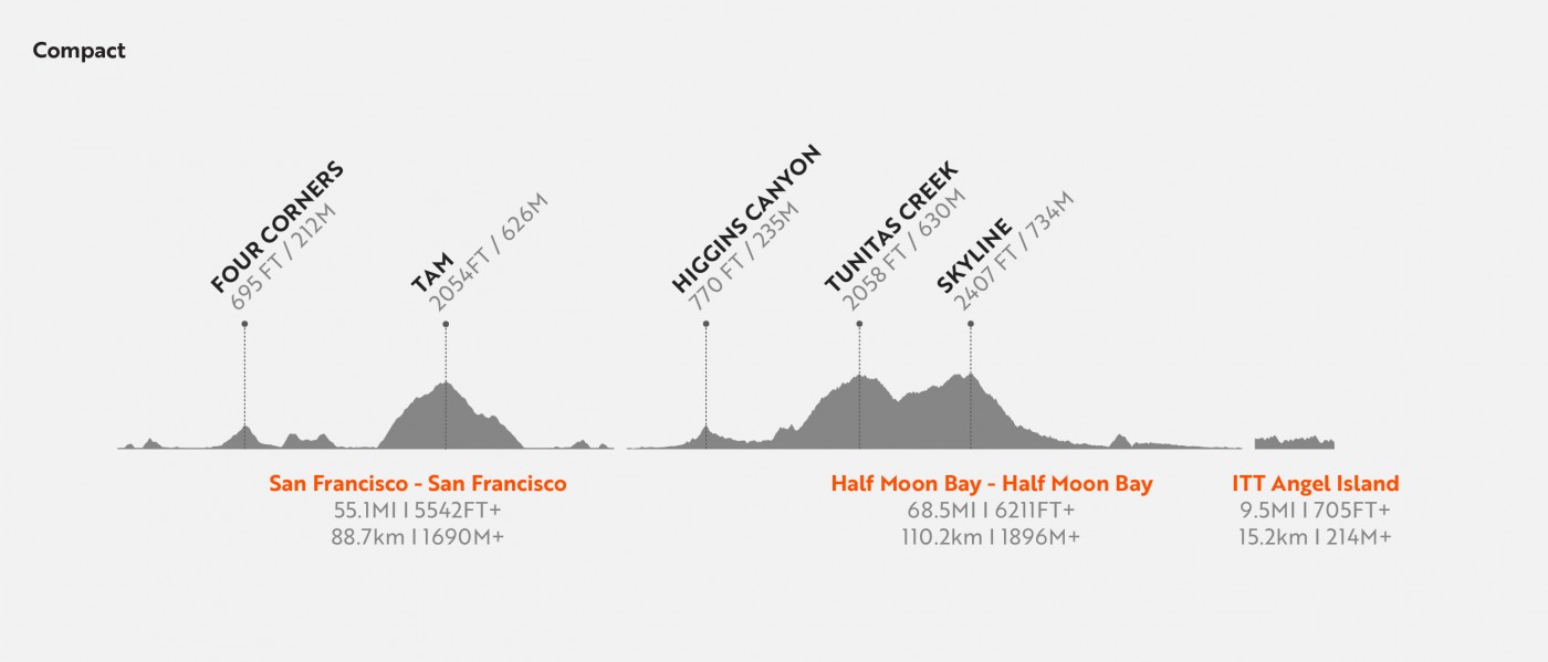
The three-stage Haute Route event, based in Fisherman’s Wharf in San Francisco from September 27-29, totals 297 km with 5122 M+ of climbing (184 mi and 16,805 ft). The route includes two crossings of the iconic Golden Gate Bridge, the ascents of Mt. Tamalpais, Tunitas Creek, and Old La Honda; and the 15km individual time trial on an island with no cars!
What to expect
Haute Route events encompass the best aspects of social rides, bike races, and cycling tours. For Stages 1 and 2, everyone starts together, riders can choose between the Original and Compact courses, and times are recorded for each rider on a number of designated segments. All riders complete the same individual time trial course on Stage 3, and there are awards for stages, age groups, and the general classification. Whether you choose to compete, pursue a personal challenge, or enjoy a great cycling weekend with friends, riders from the front of the pack to the back benefit from convenient accommodations packages, opening night pasta party, professional mechanics, safety motos, incredible feed stations, daily massages, nightly rider briefings, and more. The event wraps up early on Sunday afternoon with a celebration of shared experiences and achievements.
The Stages
Stage 1 – Golden Gate Bridge – Marin County – Golden Gate Bridge
Original: 148 km | 2387 M+ of elevation gain (92 mi | 7832 ft of elevation gain)
Compact: 88 km | 1690 M+ of elevation gain (55 mi | 5542 ft of elevation gain)
Stage 1 is a classic and unforgettable North Bay route featuring the Golden Gate Bridge, ocean views, and a ride through the Redwoods. The stage starts by crossing the Golden Gate Bridge from the south side for an early morning view of San Francisco Bay. Once through Sausalito, you’ll head up to climb part of the south side of Mt. Tamalpais before dropping down to Muir Beach.
Enjoy stunning views of the Pacific Ocean riding Route 1 through Stinson Beach and north along Bolinas Lagoon. The Compact route will turn right on Fairfax-Bolinas Road to climb up to Ridgecrest Boulevard and continue up Mt. Tamalpais. The Original course continues up to Point Reyes Station before turning inland for a long and gradual climb toward Fairfax.
Leaving Fairfax, the Original course riders encounter a roughly 5km climb up Pine Mtn. Pass, followed by a 7-kilometer winding descent to Alpine Dam. The next climb starts shortly after the dam and winds up through a towering forest of redwood trees.
From the top of Alpine get ready to tackle the “Seven Sisters”, a well-known series of climbs along the ridgeline that takes you up to the top of Mt. Tamalpais. The stunning and expansive views of the Pacific Ocean make this an unforgettable climb.
After descending Panoramic Highway and spinning your back way through Sausalito, you can once again cross the Golden Gate Bridge to reach the finish line.
Stage 2 – Half Moon Bay – Half Moon Bay
Original: 133 km | 2520 M+ of elevation gain (82 mi | 8269 ft of elevation gain)
Compact: 110km | 1896 M+ of elevation gain (68 mi | 6221 ft of elevation gain)
Stage 2 starts with a transfer to Pillar Point Pier in Half Moon Bay, and the course is well worth the drive. Starting seaside, the route will travel south before taking on the short climb of Higgins Canyon Road just 10km (6 mi) into the stage.
After gradually rolling your way back toward the Pacific Ocean the next major challenge begins with the climb up Tunitas Creek. This twisty 9km (5.6mi) climb ascends more than 450 meters (1500 ft) before crossing Skyline Blvd and descending toward Redwood City and Palo Alto.
You’ll only have about 5km (3 mi) between the end of the descent and the start of a classic South Bay climb up Old La Honda Road. This 5km climb gains more than 1200 feet of elevation as it makes its way back up to Skyline Blvd, where you’ll enjoy panoramic views from the ridgeline.
With almost all the climbing for the stage completed, both Original and Compact courses will turn toward the Pacific Ocean and start twisting and exhilarating descents. The Original course will descend to Pescadero, while the Compact course will descend to San Gregorio. Both routes end up on historic Route 1 for a very gradual – but much appreciated – downhill run back to the finish in Half Moon Bay.
Stage 2 of Haute Route San Francisco will be held in conjunction with the Gran Fondo National Series’ Jensie Gran Fondo. This one-day event, founded by legendary racer and cycling personality Jens Voigt, will share the Original and Compact courses, and add a shorter family-friendly loop.
Stage 3 – Angel Island Time Trial
15.3 km | 215 M+ of elevation gain (9.5 mi | 705 ft of elevation gain)
Stage 3 will be a unique treat, even for locals, because Haute Route San Francisco has secured all of Angel Island just for our event! Riders will take a chartered ferry to Angel Island in the morning, arriving before the island is open for tourists. You will have the opportunity to ride a warm up lap of the course, not only to stretch your legs but also to take in the incredible views. The time trial itself will consist of two laps of the 7.6-kilometer (4.8-mile) perimeter road around the island. There are no major climbs on the course, but the rolling terrain and short, punchy hills adds up to a little more than 105 meters (350 feet) of climbing per lap.
At the conclusion of the time trial, enjoy the Closing Ceremony as our chartered ferry tours San Francisco Bay on the way back to Pier 43½. You can choose to take a public ferry if you’d like to leave earlier or later than the Haute Route ferry.
Click here to find out more about Haute Route San Francisco and register.